
Every landscape architect will tell you that his work is based on the ground. This summer I'm exploring what that means, how it translates to design, and how important it is to my own practice. I'm testing 5 projects at 5 sites over 5 months.
Today and for one more month I'm on 2 + 3 near Zion National Park in southwest Utah with Peter Stempel + Form Tomorrow, a visionary architect and his equally relevant non-profit.
Today and for one more month I'm on 2 + 3 near Zion National Park in southwest Utah with Peter Stempel + Form Tomorrow, a visionary architect and his equally relevant non-profit.
 |
 |
 |
 |
 |
 |
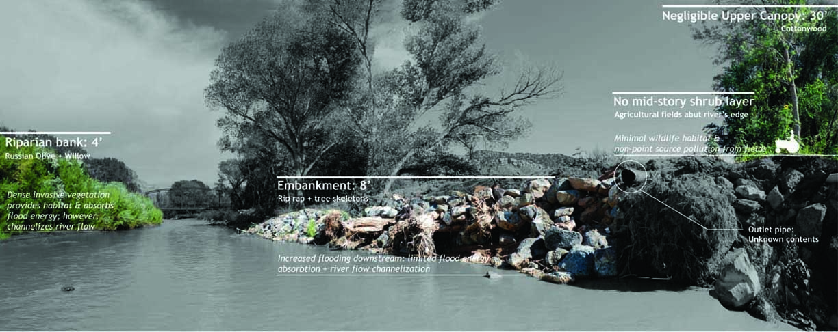
Appropriately dubbed "Wade and Map", this project complements parallel regional efforts by governmental and non-governmental organizations to survey the Upper Virgin River. Ours lies in contrast to their work, however, in that theirs relies on aerial imagery and GIS and LIDAR mapping to understand ground and water, ours relies on some of the same yes, but mostly on observations from well, the ground and water. We started simply by walking down the Virgin River. 44 miles through Zion National Park to St George, Utah through 18 watersheds, 5 towns, deep canyons, and farmland. From pristine riverine corridors to rip rap ranch embankments and riverfront second homes, we inspected every bend and undercut bank, dodging flash flood warnings, electrified barbed wire, 105-degree desert days, and tubing European tourists most of the way. I'm pleased to report that it was fun, uncomfortable at times, and invaluably productive. Walking an entire stretch of river, in addition to GIS mapping and analysis over time, allowed us to really understanding how this river and all of its tiny parts work as a system. And more importantly, to translate this data into tools and images that any planner, conservationist, or citizen can use to make informed strategic planning and localized design decisions along this valuable river and its watersheds in the future.


 |
| Virgin River Case Studies in progress, S. Dabney |
PROJECT 3
250 acre trail network on BLM, USFS + mining land (Leeds Creek. near St George UT)
This design project was kicked off not with a powerpoint presentation but with a brunch. Like many other projects, it was a reminder that working on the ground means working with people in the community. Not simply being introduced or presenting findings to them, but exchanging digits. Enjoying dinner with LoAnne and reading the articles she passes along; talking western US land politics over fried scones at Glen and Jane's; shooting the breeze with Glen at his Native American jewelry store; going to a sweat lodge with Glen's friend; going to boring and overly dramatic town hall meetings; getting a sense of the site through them and through their stories and guidance. It was one distinct morning though, pausing on a plant walk with Clarence--a Paiute elder--that the site became a place for me as I watched him watch generations of stories and sufferings, plant spirits and rock spirits, and the everything of that moment rise into the dawn as it stretched over this red cliff desert expanse.

 |
 |
We're wrapping up design of the trail system, vetting them with stakeholders including LoAnne and the community, the US Forest Service, Fish and Wildlife, and infamous Utah BLM (see the NYTimes article that came out last week) that has been a great advocate of our work and our process. Meaning the maps aren't published yet, but everyone involved--from the bureaucrats to the brunch bunch--has expressed collective interest in moving forward and ensuring the project moves forward at the same clip. Keep your eyes open for new BLM maps and trails in the Silver Reef and Red Cliffs area north of the St George mountain biking and hiking mecca for the results of our work.
After just 2 1/2 months of working on the ground, my ideas of my practice during this trial period are starting to shift beyond my 5-month horizon. Signing off for the night; Dale's stopping by early to take us on a ride in the back of his pickup to Babylon, the as-yet-unexplored-section of the area's future trail network.
After just 2 1/2 months of working on the ground, my ideas of my practice during this trial period are starting to shift beyond my 5-month horizon. Signing off for the night; Dale's stopping by early to take us on a ride in the back of his pickup to Babylon, the as-yet-unexplored-section of the area's future trail network.